
History of Bong County
Bong is a county in the north-central portion of the West African nation of Liberia established in 1964. Bong was named after Bong Range Mountain in the northeast-southern direction at elevations averaging from 600 to 1,000 feet (180- 300m) its highest point, however, is 2,116 feet. During the mid-1960s its iron-ore deposits
have been worked by the German-Liberia Mining Corporation (Delimco) and shipped via the company railroad to the port of Monrovia (50 miles southwest). In 2010, China Union took over mining activities at the Bong range previously operated by the Germans who quit mining activities as the result of the civil conflict which broke out in December 1990. The two geographical instruments in the white field portion of the flag symbolize Bong County’s mining industry. The county’s flag is purple, signifying the dawn, and orange, signifying the county’s newness. It was created in 1964, along with Nimba, Lofa and Grand Gedeh, when the administrative sub-divisions of Liberia were increased to a total of thirteen.
The capital is Gbarnga, named after an old farm in the location. It is one of 15 counties that comprise the first-level of administrative division in Liberia, it has twelve administrative districts. Gbarnga serves as the capital. The area of the county measures 8,772 square kilometers (3,387 sq mi). As of the 2023 Census, it had a population of 376,613, Male 189,551, female 187,060, making it the third-most populous county in Liberia. The county was organized in 1964 and is important for its mining industry. it is bordered by Lofa and Gbarpolu counties to the north, Margibi and Montserrado counties to the west, Grand Bassa County to the south, and Nimba County to the east. The northeast part of Bong borders the nation of Guinea. Bong County current Superintendent is Esther Y. Walker. The flag of Bong County is orange and purple with a hammer in the background as a reference to the traditional importance of mining to the local economy. Until 1964, present day Bong County was a part of Liberia known as the Central Province. The civil conflict was particularly cruel to Bong County, parts of which were contested by multiple militias over fourteen years, resulting in massive losses of life and egregious human rights abuses, especially perpetrated against women and girls. Bong County served for a time as the capital of would-be president Charles
Taylor’s “Greater Liberia”, and the area provided perhaps a majority of the children and young women that were forced to join the various fighting forces.
Most of the County’s public infrastructure and private property was looted or destroyed. While the situation has improved since the election in 2005 Government and the arrival of international peacekeepers, multilateral agencies and NGOs, there is still a dangerously high unemployment rate and a need for urgent improvements in health, education, and all sectors of the economy.
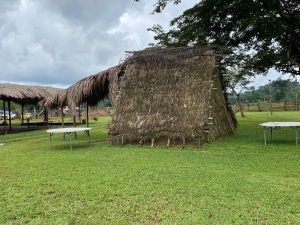
Ethnic groups found in Bong County include all of Liberia’s 16 tribes. The Kpelle people represent the largest tribal block in the County, and members of many tribes
speak the Kpelle language as a result. Although both Islam and Christianity are practiced, with Christian constituting the majority, for the most part the two groups of practitioners live amicably together. Bong County is part of the high forest belt, which can be divided into an evergreen rain forest zone and the moist semi deciduous forest zone. The evergreen forest receives an annual rainfall of 80 inches and consists of species that do not have a marked period of leaf fall. The tallest trees reach 200 feet. The County is said to be well-watered by six principal rivers and a number of small streams.
The soils of Bong County are mostly latosols, which occurs on undulating and rolling land and occupies about 18% of the total land area in Liberia. This soil is heavily leached and silica nutrients and humus are readily washed out. Over the years, many investments and development initiatives of national importance has been undertaken in Bong County.
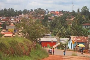
Bong County is situated in the central part of Liberia. The main paved road that runs from Monrovia to Sanniquellie in Nimba County traverses Bong County